


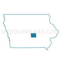
LAMBS GROVE Voting District, Jasper County, Iowa
About
Outline

Summary
| Unique Area Identifier | 582428 |
| Name | LAMBS GROVE Voting District |
| County | Jasper County |
| State | Iowa |
| Area (square miles) | 0.10 |
| Land Area (square miles) | 0.10 |
| Water Area (square miles) | 0.00 |
| % of Land Area | 100.00 |
| % of Water Area | 0.00 |
| Latitude of the Internal Point | 41.70075300 |
| Longtitude of the Internal Point | -93.07934910 |
Maps


Graphs
Select a template below for downloading or customizing gragh for LAMBS GROVE Voting District, Jasper County, Iowa


Neighbors
Neighoring Voting District (by Name) Neighboring Voting District on the Map
- NEWTON TWP PART W/O LAMBS GROVE & NEWTON Voting District, Jasper County, IA
- NEWTON W/NEWTON TWP & PALO ALTO TWP PARTS Voting District, Jasper County, IA